When creating models for teaching non-sighted students, choosing the right level of detail is an enormous challenge. On the one hand, teaching materials should transfer as much knowledge as possible and enable a great increase in cognition – on the other hand, teaching materials for non-sighted students should not be overloaded with information. The question of the level of detail must therefore play a major role in the planning and digital design of the model and be in mind from the outset. This article describes strategies and solutions for this dilemma.
Danger of information overload
In a sighted world, models and illustrations can be used to transfer enormous amounts of information. For example, diagrams, charts, cross-sections, etc. help to make information easier to grasp and understand than by reading a plain continuous text. For non-sighted people however, the situation is often the opposite. Here, working with a model or a tactile illustration is usually a huge challenge. The representation in the form of a tactile illustration or a model often appears complicated for non-sighted pupils. Mental pictures and deeper understanding are not automatically achieved through the provision of teaching aids.
This danger is increased if the quality of the model is poor. Overloaded illustrations can lead to their rejection by blind students of average ability. Beyer believes that “… reducing the presentation of tactile illustrations and maps in education for the blind to the essentials is one of the main requirements of tactile media – if not the most important” (Beyer, 1995, p. 32). However, it must be taken into account that generalisations are not possible here either. “The information content of a presentation depends on what is to be conveyed and to whom it is to be conveyed. With regard to the selection of information, there are no binding rules; rather, it depends on the purpose of the representation and the individual abilities of the user” (cf. Lehmann 1990, p. 58 after Bentzen 1980, p. 301).
As a consequence, when designing a model, the first thing to consider is which components can be eliminated in order to reduce the teaching material to the central core.
Distribution of information over several models
Reducing the information, as described above, always has its limits and if a large amount of information is to be transferred with the help of a teaching aid, the distribution of the information over several models is a reasonable solution. Especially for non-sighted students with little experience in dealing with models, tactile illustrations and maps, it is advisable to distribute the information and labelling over several media with increasing information content – but on the same scale (cf. Lehmann 1990, p. 58 after Bentzen 1980, p. 301).
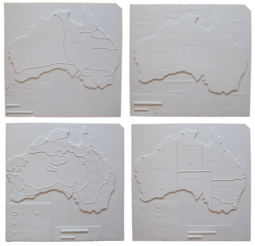
Best practice: Map of Australia
The following example shows the approach taken in the production of a tactile map of Australia. Information was distributed over several maps which were not produced with the help of a 3D printer but with a CNC milling machine and a vacuum forming machine. Since this article focuses on the teaching method, the different production process does not play a role.
Often maps that are made for sighted people are characterised by an enormous level of detail. When designing a tactile map, there is a risk that a visual map will be used as a template. In terms of the map of Australia, if a visual map were to be converted directly into a tactile map, the level of detail of the coastline, for example, would exceed haptic perception capabilities many times over. Similarly, visual maps of Australia often show many small islands off the coast. If all these small islands were to be represented on the tactile map, this would make the coastal contour more difficult to distinguish. To simplify the learning content, these details should be eliminated, as they are not the focus of the exercise.
In this case however, the simplification is not limited to the coastline. It applies in particular to the level of content. There should not be too much information on the map if the map is to be used in lessons with younger or less experienced pupils. It is better to distribute the information to be presented over several maps with increasing information content. In this case, it is very important to limit the information to the essentials and to avoid details.
In concrete terms, this means that four different maps were produced:
- major cities and states,
- railway lines
- landscape features
- climate zones
Outsourcing information
In principle, braille labelling can work very well on 3D printed models, as described in detail in Article 3. Braille or 3.7 Labelling with Braille. However, the problem is often that there is not enough space for detailed labelling. When exploring the model, it must not be overloaded with too much text. The use of alternative techniques to supplement the model with information through speech, NFC or QR codes is described in Article 6.3.
Well-designed materials for teaching non-sighted pupils sometimes consist of a combination of model and swell copy. For example, a volcano to capture the spatial component (topography) could be produced with the 3D printer. A complementary swell copy of the cross-section could provide additional information about the structure. This combination would not only have the effect of ensuring an ideal distribution of information, but would also promote an understanding of the cross-sections of objects.
References
Beyer, Martin (1995). Aspekte der Gestaltung und Herstellung taktiler Medien anhand ausgewählter Beispiele. In: Wilfried Laufenberg, & Jürgen Lötzsch (Hrsg.): Kolloquium über tastbare Abbildungen für Blinde. Marburg: Deutsche Blindenstudienanstalt
Lehmann, Kerstin (1990). Handbuch des taktilen Kartenbaus. In: Der Bundesminister für Arbeit und Sozialordnung (Hrsg.): Handbuch des taktilen Kartenbaus. zit. nach Bentzen, B.L. (1980): Orientation Aids. In: Blasch, B.B.; Welsh, R.L.: Foundations of Orientation and Mobility. New York